
Lesson Plan - The Relocation of the Cherokee in North Carolina
A Lesson Plan for Grade 8 Social Studies
By Jennifer Job, School of Education, UNC-Chapel Hill
Students will demonstrate an understanding of the movement of the Cherokee population in North Carolina. Students will show the geographical changes of Cherokee land from the 18th to the 19th centuries through an understanding of maps, writings about the tribe, and the Treaty of 1819.
Time Required: Two 90-minute class periods
Materials and Resources:
- Smartboard or other projection that can be drawn on
- 1819 Cherokee Treaty (.pdf)
- Access to the Joint Resolution of 1834
- Access to William Bartram's Travel Journals
- Student journals or paper
Teacher Instructions:
- This lesson should precede instruction on the Trail of Tears. Explain to students that they will be learning about the European impression of the Cherokee Indians and how that impression affected their forced movement.
- Ask students to take out their journals or paper to write on. Have them access William Bartram's Travel Journals. Have them look at the faceplate of the Cherokee Indian at the front of the book. Explain to them how to use "find" (Ctrl F) to find every reference Bartram makes to the Cherokee Indians. Ask them to read the sentences about the Cherokees and write down:
- a) A three sentence description of what a Cherokee looks like
- b) Seven adjectives Bartram uses to describe the Cherokees
- c) Five activities Bartram does with the Cherokees or witnesses them doing Discuss their answers with the class, and ask them to synthesize their answers into an explanation of how the American colonists viewed the Cherokees.
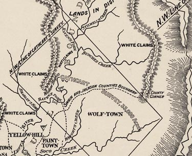
- Project a copy of the A New Map of the Cherokee Nation (1760) on the Smartboard. Discuss with the students the features that they see. Then project A Map of the American Indian Nations (1775) and ask them to find the Cherokee areas (notice that there are different spellings) in North Carolina. Draw a line around the area that belonged to the Cherokee tribe (this information can be found at Original Cherokee Claims). Discuss what major towns and features are found in this area. Ask students to conjecture what difficulties might arise from this clash of cultures, and instruct them about the wars that took place in this time period.
- Project A New Map of Southern Dominions (1794) on the board, and draw a line around the area that belonged to the Cherokee in that time period. Remind the students that this is now after the Revolutionary War and that Americans were trying to build their country and define the states. Give students a copy of the 1819 Cherokee Treaty to read. Ask them to underline every reference to land movements and Indian removal. Then, using their newfound knowledge, use a different color to show the movement of the Cherokee Indians on the 1794 map. Note how the Cherokee are almost completely removed from North Carolina.
- Finish the lesson by asking the students to read the Joint Resolution of 1834. Ask the students to summarize the outcome of the Resolution (that Cherokee Indians be completely removed from North Carolina). Discuss with the students what the tone of the document is—how do North Carolinians view the Cherokee Indians in 1834? How is it the same or different than how William Bartram viewed them?
Assessment Activity: Discuss with students the repercussions of removing an entire group of people from an area. What was lost by removing the Cherokees? In their journals or the paper from before, ask them to imagine what it would be like if they were forced to move from their homes. What would they feel? What would the town be missing if their families were to leave? Collect the writings for assessment.
North Carolina Curriculum Alignment
Goal 3: The learner will identify key events and evaluate the impact of reform and expansion in North Carolina during the first half of the 19th century.
- 3.05: Compare and contrast different perspectives among North Carolinians on the national policy of Removal and Resettlement of American Indian populations.