
Shaping North Carolina, 1500-1775
by H. G. Jones
This paper was presented at "The Southeast in Early Maps," a conference on historical cartography held in Chapel Hill on October 3-4, 1997. This online version is published with permission of the author.
It is daunting for a historian to become involved with a subject so fraught with complexity and controversy as cartography, but if Bill Cumming, a professor of English, could become the leading authority on maps of an entire region, perhaps a historian pausing at Halfzheimer on the way to Alzheimer has nothing to lose by taking a look at a few maps that help trace the emergence of North Carolina as a geographical entity, the outline of which every school child a half century ago learned to draw. It is not my purpose today to plow new ground, to contribute to the art and science of mapmaking, or to acknowledge disagreements among those who study maps and their implications. I simply want to follow the gradual shaping of North Carolina through a selection of maps from the periods of exploration, proprietary rule, and colonial status.
Three caveats: (1) There are literally hundreds of early maps covering the area now denominated North Carolina, and I have time to mention only a few, selected rather arbitrarily; (2) my slides are amateurish, often photographed from printed maps, sometimes from poor copies at that; and (3) I have reoriented several slides to the north.
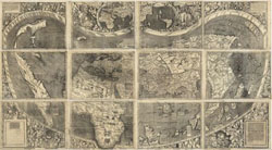
Martin, Waldseemüller, "Universalis cosmographia," 1507. Click on the map to view the full image and description at the Library of Congress online collection, American Memory.
At the time of the 1486 German printing of Ptolemy's map of the world, educated people understood that the earth was round; it was therefore assumed that one could sail west to get to the Orient. Imagine the confusion, therefore, when seamen returned to Europe with reports that they had reached lands that did not fit the prevailing image of the Orient. Only eight years after Columbus's landfall, Juan de la Cosa's map depicted the temperate islands reached by the Spanish as well as cooler lands bordering "the sea discovered by the English" far to the northeast. Cosa's map raised two questions: Had there been European exploratory cruises along a mainland north of Isabella (Cuba), thus confirming a continuous landmass connecting the rivals' claims? If so, had this landmass been recognized as a part of a new continent rather than of Asia? The second question was soon answered, but the first remains a matter of controversy nearly 500 years later. But inasmuch as I am not concerned with the controversy, let me simply observe that among the earliest maps that may possibly have been based on unrecorded voyages along our southeastern shores are the Cantino (1502) and Waldseemuller's 1513 edition of Ptolemy. We have more confidence in Juan Vespucci's map of 1526 because, despite its defects -- e.g., English and Portuguese discoveries in present-day Canada are depicted as an island, and the area north of Florida turns too sharply to the east -- the voyages of Giovanni da Verrazzano and Louis Vasques de Ayllon are recorded. Happily, Vespucci's map preceded by some months the colonization attempt by Ayllon and therefore does not answer continuing questions of its exact location. Having in my North Carolina Illustrated innocently assumed that this early colonization attempt occurred on North Carolina's Cape Fear River, I leave it to South Carolinians and Georgians to argue over exactly where Ayllon's followers sought to plant a new colony. But with Verrazzano we are on sound ground, for in 1524 the Florentine in the service of France gave us the earliest known description of North Carolina when he reported finding near Cape Fear "a new land which had never been seen before by any man, either ancient of modern." Farther up the coast, Verrazzano looked across the Outer Banks to the Pamlico Sound and reported, " . . . we could see the eastern sea from the ship . . . . This is doubtless the one which goes around the tip of India, China, and Cathey." The mainland to the west being invisible from the Dauphine, he concluded that the banks formed an isthmus, which he named "Verazanio" for himself. Had he found an inlet and reached the mainland, he probably would have assumed our coastal counties to be "those blessed shores of Cathay." Enough mischief resulted from Gerolamo da Verrazzano, who in 1529 incorporated his brother's misconceptions into a huge map. The mythical Sea of Verrazzano -- in the middle of which, if it had existed, we would be sitting today -- was engraved onto the Robert de Bailly copper globe that was acquired by the king of England the next year, and the misconception plagued mapmakers for at least a century. Nevertheless, Verrazzano's is one of the first maps to record the continuous exploration of the Atlantic coast from Florida to the Newfoundland-Cape Breton area.
Diego Ribero's world map of 1529 has special significance to North Carolina because it locates the Bay of Santa Maria, assumed by Cumming to have been present-day Pamlico and Albemarle sounds. We can see the Bay of Santa Maria on succeeding maps, including a colorful Dutch map of ca. 1540; another by Jean Rotz, 1542 (who, incidentally, may have been the first cartographer to picture an Indian teepee); the "Harleian," 1547 (which moves Verrazzano's sea southward to near Port Royal); and LeTestu, 1555. Munster, 1540 moves Verrazzano's sea northward, and as late as midcentury (1555), the Grynaeus map labeled North America "Terra de Cuba," a cigar-shaped continent just east of Japan.
Thus the state of geography was still primitive when Walter Raleigh began plans to send a colony to North America. Raleigh and his advisors no doubt had access to various maps produced in Spain, Portugal, and France, but the English too had produced a few. That Englishmen still believed in the myth of a western ocean only a short distance from the Atlantic was indicated by Richard Hakluyt who in his "Particular discourse" wrote that "the North-west passage to Cathaio and China may . . . be searched out as well by River and overlande as by sea." Interestingly, though, a chart of the Atlantic coast drawn in 1580 by Simon Fernandes does not commit itself to what lies beyond the coastline. Perhaps the pilot of the future Roanoke voyages didn't care, for, as Cumming states (Mapping the North Carolina Coast, plate 19), Santa Maria was "strategically located for preying on Spanish shipping, and for this profitable Elizabethan sport Fernandes had an obsession, as did most seafaring Englishmen."
Identifiable cartography of North Carolina began, of course, with the English landings of the 1580s. A sketch-map made in 1585 by an unknown hand is particularly significant, for it carries specific identification of "the port of saynt maris wher we arived first." Apparently based partially on le Moyne's map of Florida, John White drew his magnificent La Virgenia Pars which, like Vespucci's, distorts the directions of the lower Carolina coast. The map also displays a large body of water to the west of Port Royal, still suggesting a sea of Verrazzano. This was, to 1585, the best map of southeastern North America. Even better for North Carolina is a separate watercolor of the coast and Outer Banks, Virginea Pars extending to only slightly below Cape Lookout. The relative accuracy of this map is demonstrated dramatically by comparison with a photograph taken from space.
Theodore de Bry, "Americae pars, Nunc Virginia," 1590. North Carolina Collection. Click on the map to view the full image and description..
John White's beautiful watercolors were seen by only a few individuals, but, based on the drawings and accompanying Thomas Harriot's narrative, Theodor de Bry's engravings became available to readers of several languages in 1590. Just two examples: A close-up of the area around Roanoke Island, oriented to the west, shows inlets, navigation dangers, and Indian villages. Also oriented to the west is a map of the larger area from below Cape Lookout to the Chesapeake. One of the first maps to label "Virginia" was "The famous West Indian voyadge" of Sir Francis Drake, printed after Drake's 1585-86 cruise during which he gave most of Ralph Lane's colonists a lift back to England.
I cannot resist correcting a widely-believed error concerning Walter Raleigh and North America, even if, as in the most recent case, the error is committed by the Librarian of Congress in the magazine Civilization. To be fair, I must also fault the officials of our historic county of Chowan who in 1772 adopted a county seal showing Raleigh, in a tricornered hat, no less, greeting two Indians on the North Carolina coast; beneath are the words, "Sir Walter Raleigh landed in America A.D. 1584." This penchant for correction explains the inclusion in your registration packet of a wine license disproving the claim that Raleigh's name was never spelled during his lifetime with an "i."
Additional attention was directed to the region that would become North Carolina when Jodocus Hondius produced for Mercator's Atlas in 1606 Virginiae Item et Floridae Americae Provinciarum nova Descriptio, based on de Bry's engravings of White's Virginia and le Moyne's Florida. For nearly three quarters of a century this was the most important type map of the region.
Virginians have never been very generous toward North Carolinians, so perhaps we should have expected that John Smith's "Ould Virginia" of 1624 would be little more than a crude copy of earlier maps. Furthermore, Smith tried to perpetuate several place names, presumably for the sake of flattery - Abigail's Ile, Cecil's Harbor, Port Vaughan, Port Corbett, etc.
The evolution of a map is illustrated by an amateurish 1650 manuscript, "Ould Virginia 1584 Now Carolana 1650 New Virginia 1606 . . .," by John Farrer. This and its printed version may be the only maps to identify the colony as Carolana, the name given to the grant of land from King Charles I to Sir Robert Heath in 1629. Heath failed to carry out his plans to establish a colony of French Protestants, so when the area was regranted to the eight lords proprietors in 1663, the name was changed to Carolina in honor of Charles II. Farrer's printed map is especially interesting because of its details and its nomenclature of "Rawliana" and a notation in Albemarle Sound of "Rolli passa," presumably by another believer that Raleigh came to North America. Farrer pushed the Sea of China and the Indies just across the Appalachian Mountains where, according to the map, it is within ten days' march from the head of the James River. Observe the credit line - Virginia Farrer (she was John's daughter). Is this the first map of North America to bear a woman's name?

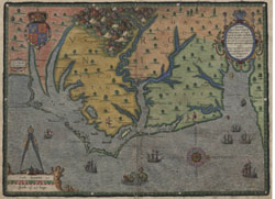
Nicholas Comberford, "The South Part of Virginia." Click on the map to view it online in the New York Public Library Digital Gallery.
A few maps document significant personages or events. Of special interest is Nicholas Comberford's manuscript in the New York Public Library, "The South Part of Virginia" with a subtitle added by another hand, "Now the North Part of Carolina." Described by Cumming as "more accurate and detailed than any previous map" of the Carolina sounds, it also applies place names that survive today. These virtues are often overlooked by North Carolinians who assume that its value lies only in its location of the first known dwelling house in the colony, for near the confluence of the Chowan and Roanoke rivers are a symbol and the words, "Batts House." That Nathaniel Batts was indeed one of the earliest settlers in the Albemarle is also attested to by other manuscripts, such as court papers in Lower Norfolk County (Virginia) relating to a lawsuit of Robert Bodnam, who sought payment for "going twice to the Southward and staying there 5 Monthes" to build a house "for Batts to live in and trad with the Indians." Unfortunately, because the Comberford map was not printed and therefore was unavailable to other cartographers, inaccuracies based on earlier maps continued to be perpetuated.
About the time Nathaniel Batts (and no doubt other Virginians) took up residence in the Albemarle, activity began in the Cape Fear region. Based on information gained from William Hilton's explorations of the river and from aborted colonizing attempts by separate groups from Charles Town, Massachusetts, and the Barbados, several colorful manuscript maps are preserved in the Blathwayt Atlas in the John Carter Brown Library. Without title, date, or attribution, Number 19 egregiously misspells names applied to the area by Nicholas Shapley, whose now-lost map was copied by John Locke in 1662. For example, Locke's modest "James Fort" -- which was probably meant to read "James Bates," the name of one of the hopeful settlers -- was magnified into a mighty fortress flying a lovely flag. Maps do sometimes lie.
Number 18 in the Blathwayt series so badly distorts the direction of the Cape Fear (here Charles) River that both the Pamlico and Neuse are cut off from their Piedmont origins. Interestingly, though, it records names given to places by Hilton and the Barbadian settlers such as Rocky Point, Stag Park, and Turkey Quarters. Number 20 in the Blathwayt collection changes the name from Charles River to Cape Feare River and does a fair job of recording now-familiar names for other rivers and capes. Fortunately, Blathwayt Number 21, though untitled, is identified as "Made by James Lancaster: Anno Domi: 1679." Here is a wonderful view of Albemarle Sound with more than twenty red-roofed houses, only one of them, Whitty's, labeled. Among the other landmarks is an unidentified house at the junction of the Chowan and Roanoke rivers. Nathaniel Batts's, one might logically guess.
I have substituted for the first printed map after the proprietary grant -- the one accompanying Robert Horne's 1666 promotional pamphlet, A Brief Description of the Province of Carolina . . . -- another crudely copied from it six years later, Richard Blome's A Generall Map of Carolina. Both Horne and Blome were obviously currying favor with the Lords Proprietors, but Blome was shrewd enough to display the coat-of-arms of each of them. These maps emphasized the Charles (that is, the Cape Fear) River, depicting short-lived "Charles Town" and other place names found on one or more of the Blathwayt manuscripts. Absence of common nomenclature is revealed in the substitution of Cape "Hope" for Lookout.
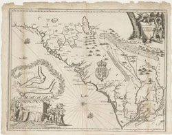
John Ogilby, "A new discription of Carolina by the order of the Lords Proprietors." North Carolina Collection. Click on the map to view the full image and description.
In 1672, John Ogilby's attractively engraved "A New Discription of Carolina by Order of the Lords Proprietors" incorporated the misconceptions of John Lederer to the point that it is useless for a study of the interior. John Speed's "A New Description of Carolina," 1676, was little more than a copy of Ogilby without the Ashley-Cooper River inset. With the settlement around 1670 of a new Charles Town in southern Carolina, the Ashley-Cooper area became the focus of attention from both the Lords Proprietors and mapmakers, and so for more than a half century there were few detailed maps of the northern portion of the colony.
John Lawson's rather amateurish 1709 map of Carolina is often dismissed, but it does contain some new information. For example, the colony's first town, Bath, appears, as do the names of several planters and Indian settlements, the three counties (Albemarle, Bath, Clarendon), and five precincts (Currituck, Pasquotank, Chowan, Wickham, Archdale).
In the shaping of North Carolina, Homann's map of Virginia, Maryland, and Carolina, 1714, only confuses. Florida, for example, extends up to Pennsylvania and Lake Erie. Carolina is given to the location of the aborted Massachusetts/Barbadian settlements on the Cape Fear.
I have included Henry A. Chatelain's tiny 1719 "Nouvelle Carte de la Caroline" simply to inform you great map collectors that I, too, own a map -- one map. It is useless for scholarship, but I can cite it to "prove" that there were once a desert in the Piedmont, a savanna on this side of the Blue Ridge, and a "Hot Bath" somewhere along the Neuse River. I wonder if the latter reference could be to present-day Seven Springs.
At last, at last, there appeared a really useful map of the colony. Edward Moseley, who probably held more government positions than anyone else in North Carolina's history, left us a document of utmost significance, and we could spend many sessions on his "A New and Correct Map of the Province of North Carolina," 1733. It is incomparable in several respects. First, even with only the northern boundary marked, the colony, which since 1711 had been administered separately from South Carolina, takes on a fairly accurate shape; second, most of the streams are reasonably correct in their orientation; third, Moseley's place names have for the most part survived to our day; and fourth, he added features seldom found on maps -- names of many residents, navigational aids to ships, and statistics on the American Indians who had survived nearly three quarters of a century of European incursion. Regrettably, this, the only copy of the Moseley in North Carolina, owned by East Carolina University, is so dark that a really good photographic copy is impossible, and even more regrettably, the Kendall copy in South Carolina, from which the illustrations in The Southeast in Early Maps were reproduced, is rumored to have disappeared. Possibly the only other extant copies are in the Public Record Office in London and at Eton College. If we could produce a better slide, you could follow the road from South Carolina through Brunswick Town, New Bern, Bath Town, and Edenton into Virginia, as well as the Indian trading path running from the James River to the Cherokee country. We could see the general location of courthouses and rural chapels, of scores of plantations, of Indian settlements, and of the location of ore "of a Sulpherous smell." In this detail copied from Cumming's reproduction, we can follow settlements up the fertile Cape Fear valleys and we can see that lands were being taken up west of Lake Waccamaw, perhaps to help bolster North Carolina's boundary claim against South Carolina. A Welch settlement is shown up both branches of the Cape Fear, along with a mysterious "Palatine Settlement" near the juncture of Rockfish Creek and the Cape Fear. Immensely useful insets, with water depths for sea captains, are provided for Beaufort and Brunswick (with "Barren Head" on Smith Island), and also Ocracoke. Even "Thatches Hole" is shown at Ocracoke; remember that this was only fifteen years after the beheading of the dreaded Blackbeard. And, in a box titled "Explanation" Moseley gives estimates of the Indian population and assures vessels in distress that crews need not fear coming ashore -- "nor is there any danger from Indians, none now Inhabiting the Sea Coast, but about 6, or 8, at Hatteras, who dwell among the English." Finally, a fascinating drawing of a whale hunt reminds us of that long-forgotten activity in North Carolina's history.
Less detailed than the Moseley but more useful from a navigational standpoint are James Wimble's hydrographic charts. As early as 1733 Wimble drew a rough sketch of the coast. Interestingly, "New Carthage Town" on the original drawing had become Wilmington when Wimble's more detailed map was printed five years later. Although fewer than on Moseley, Wimble too located many plantations.
Understandably, the sparsely-settled interior of North Carolina remained a mystery on early maps, but by the middle of the eighteenth century movement had accelerated both from the east and north. As the English took up lands along the eastern rivers, so Scots by the 1740s were pushing up the Cape Fear, and Ulster Scots and Germans began coming down the Great Wagon Road from Pennsylvania to the Yadkin. Among the latter were the United Brethren (Moravians) who obtained a huge grant of land from Lord Granville and laid out Wachau (Wachovia), clearly shown on the Joshua Fry-Peter Jefferson 1750s map of Virginia, along with the Great Wagon Road from Pennsylvania. Within a decade the Moravians had built three congregational towns, Bethabara, Bethania, and Salem, which introduced to North Carolina a level of culture and industry absent during its first century and never replicated anywhere else in the colony.

John Mitchell, "A map of the British and French dominions in North America." Click on the map to view it online in the New York Public Library Digital Gallery.
John Mitchell's "A Map of the British and French Dominions in North America," 1755, is of interest because it provides a boundary, albeit inaccurate, of the colonies. The Indian Trading Path through nearby Aconeechy (Hillsborough) is a prominent feature. In present-day Bertie County is the notation, "Tuscarora Indians now removed," a sad commentary on the exile to New York of remnants of the once-proud natives of the region. The extension of the Carolinas beyond the Mississippi River reminds us that the Carolina Charter of 1663 extended to the Pacific Ocean, and a lot of Mexicans and Californians do not know that except for subsequent political events, they might be saying "y'all" and wearing Carolina blue.
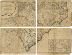
Its title is a little immodest, but "A Compleat Map of North-Carolina" by John Collet, 1770, based heavily upon previous surveys by William Churton, stands as the first generally reliable image of North Carolina, including a dividing line with South Carolina. Some streams are traced to their origins as far as the Blue Ridge. The Moravian towns have been joined by Salisbury and Charlottesburgh; roads crisscross the Piedmont; and mills, ordinaries, and a few large plantations -- such as Thomas Lloyd's (just outside of Carrboro on Old NC 86) -- dot the landscape. Crossing roads mark the site that 25 years later would be occupied by this university. We are fortunate that John Collet, then governor of Fort Johnston, completed and had his map printed in London at his own expense five years before the outbreak of the American Revolution, when rebel forces unceremoniously burned his house at Fort Johnston as he watched helplessly from a British sloop, to which he had fled. This is a map worthy of several sessions.
Henry Mouzon, "An Accurate Map of North and South Carolina With Their Indian Frontiers." North Carolina State Archives. Click on the map to view the full image and description.
The 1770 Collet was the basis for the North Carolina portion of "An Accurate Map of North and South Carolina . . ." by Henry Mouzon, Jr., 1775. Mouzon corrected some of Collet's distortions, but as a native of South Carolina, he was primarily interested in improving upon James Cook's 1773 map of that colony. Among additions, Mouzon included a change in the boundary between the two colonies in the vicinity of the Catawba Nation below Charlottesburgh; and place names and coastal soundings are more accurate. Ironically, Mouzon's house was also burned during the Revolution -- but by the British -- and he was permanently crippled in his fight against the army that made such effective use of his map during the war. Indeed, this was the map used by both American and British forces.
Except for minor boundary changes north and south, the eventual separation of Tennessee, and nature-caused topographical changes since the emergence of the new state two centuries ago, the outline of North Carolina had been pretty well fixed by 1775. With every generation, of course, have come cartographic improvements, but still nearly every visitor to the North Carolina Collection Gallery pauses at the entrance, studies the 222-year-old Mouzon wall map, and seeks orientation. This afternoon we will hear about revolutionary changes in mapmaking -- changes that in the future will give us more a accurate image of our state and world. However, lest we lose appreciation for the work of cartographers who over the centuries have given us our present image of our surroundings, let me close with two simple examples of the evolution of maps in the past. The first is William Churton's plat of the Duckenfield plantation in present-day Bertie County, dated 1767. The earliest known dwelling house in North Carolina, that of Nathaniel Batts in 1655, stood near the mouth of Salmon Creek, and perhaps improvement in the science of archaeology will some day identify the exact site. But aside from that hope, we can benefit from the enormous amount of information contained in this small document: the locations of homes and the roads connecting them, the size of plantations, and the intriguing reference to "Shipyard" and "Tombstone Land." Surviving property surveys such as this have helped mapmakers for centuries, and imagine the picture that they can present for an entire region if placed side by side.
Finally, road maps. We take them for granted, and Ed Dahl couldn't get back to Canada without one. Among the few surviving early road maps is one preserved at the University of Michigan dated about 1775 (North Carolina was still a "province") and extending from near Wilmington to various northern and western points, including Pilot Mountain, Salisbury, and Charlottesburgh. It records distances between plantations and streams, lists bridges and ferries, and assures travelers that other river crossings were "fordable." Odometers were not then common, but this eighteenth-century map estimated the distance from Wilmington to Chapel Hill to be 175 miles. The 1997 state highway map places the mileage at 151. Assuming the accuracy of both, it has taken us two and a quarter centuries to reduce the road distance by only 24 miles but the time of travel from three days to three hours. Who says that maps don't teach us anything?
Dr. H. G. Jones is Curator Emeritus of the North Carolina Collection and Professor Emeritus of History at the University of North Carolina at Chapel Hill, where he is currently the Thomas Whitmell Davis Research Historian. Prior to coming to UNC-Chapel Hill, Dr. Jones served as State Archivist of North Carolina and Director of the North Carolina State Department of Archives and History. He is the founder and secretary of the North Caroliniana Society. He has written widely on North Carolina history, including the state historical column "In Light of History," which was distributed by the Associated Press for seventeen years, and the books North Carolina Illustrated and North Carolina History: An Annotated Bibliography.