
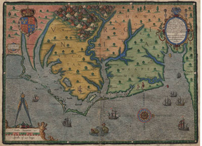
Theodore DeBry, "Americae pars, Nunc Virginia," 1590. Click on the image for a full view and description of the map.
The mapping of the area we now call North Carolina began in the sixteenth century from early exploration. The first British settlement in 1585 was mapped showing Cape Fear as well as several Native American villages. Here we see a depiction of the area the British called, "Virginia." This map, printed in 1590, is a good example of the early maps of the period. Look at the compass in the bottom right area. North is actually to the right rather than pointing to the top. These maps are colorful and imaginative, depicting ships, sea-monsters, mountains, and Native Americans. See if you can identify the Outer Banks on this map. Can you find the Native American Villages?
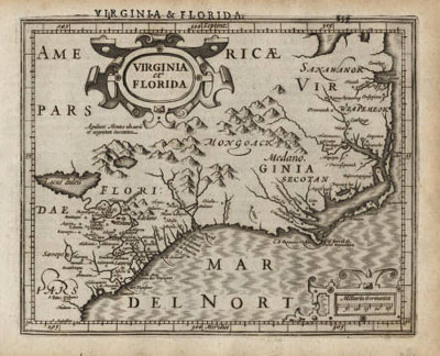
Later maps left out the sea-monsters, but they still depicted ships caught in tidal winds. You can also see many of the islands of the Outer Banks. By the time of this map, published in 1610, there was an area the Spanish termed "Florida" south of Virginia. Several towns are along the cost of the Mar Del Nort, or the "Sea of the North." There was still no land termed "Carolina," but can you see the name "Americae" engraved in the top?
![Virginiae partis australis et Floridae partis orientalis interjacentiumq[ue] regionum nova descriptio, ca. 1640](images/map_history_k12_3.jpg)
"Virginiae partis australis et Floridae," circa 1640. Click on the image for a full view and description of the map.
This map, published around 1640, shows a much clearer picture of the coast and looks more like what we see in maps today. There are many towns shown by the Outer Banks, and cartographers, or mapmakers, stopped drawing a sea to the west. The explorers knew by then that the land stretched much farther west than they had previously thought.
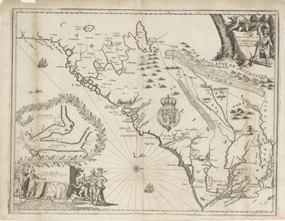
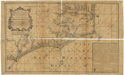
"A new discription of Carolina by the order of the Lords Proprietors," circa 1671. Click on the image for a full view and description of the map.
By 1663, letters from the Lord Proprietors of the settlements began to refer to a province called "Carolana" (named for the British king Charles I) between Florida and Virginia. By the 1670s, maps were clearly showing Carolina as a separate province. This map, published in 1671 and called "Description of Carolina by the Order of the Lords Proprietors," shows the new province. At the time, the Lord Proprietors described Carolina as "lying southward of Virginia . . . enjoys the fertility and advantages thereof . . . on the main continent of America, between the degrees of 30 and 36 . . . 30 degrees bound by Virginia and 36 degrees bound at the south, yet not fully explored, but bound by the east by the Mare Atlanticum and by the west the South Sea." Can you see the name of the mountain range? How close is it to what we call those mountains today? Also, look for the Coat of Arms on the map. The creator, John Ogilby, obviously wanted the current monarch in power to use the map!
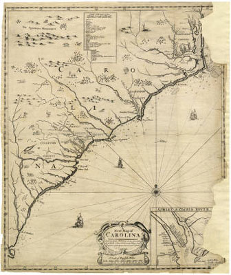
"A New Map of Carolina," 1685. Click on the image for a full view and description of the map.
This map, drawn in 1685, was sold in a London at a toy and china-ware shop. It clearly shows the Carolina area, including the Ashley and Cooper rivers near Charles Town. This map shows the area with the top pointing to the north, much like maps we see today. Can you see the animals depicted on the map? The top table lists all of the known settlements on the coastline. By the late 17th century, exploration of the area of Carolina was fully underway, although the travelers mainly went south instead of west into the mountains.
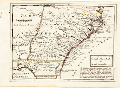
"Carolina," 1729. Click on the image for a full view and description of the map.
By the beginning of the 18th century, the various land owners began to push for a clearer boundary between Virginia and Carolina, considering the crop boom that was occurring there. In 1710, two governors, on behalf of Queen Anne, pled for a firm boundary to be drawn between the two provinces. Their main complaint was that the Native Americans from Virginia were encroaching on the lands of Carolina . The Governor of Virginia apologized profusely, and after much negotiation, the boundary was made in 1723. Meanwhile, in 1712 , North and South Carolina made an official split. This map, drawn in 1729, shows the boundary of North Carolina and Virginia and the one between South Carolina and North Carolina. The bottom right corner describes the British claims of the land. Can you find any towns that have familiar-sounding names? Can you find Albemarle and Bath?
"Chart of his Majesties Province of North Carolina," 1738. Click on the image for a full view and description of the map.
How about in this map, drawn in 1738? Can you find familiar names?
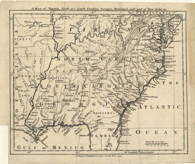
"A Map of Virginia, North and South Carolina, Georgia, Maryland with part of New Jersey etc.," 1755. Click on the image for a full view and description of the map.
By the mid-1700s, the lines between Virginia, North Carolina, and South Carolina were drawn, but the land to the west was owned by the French. This map, dated 1755, shows Louisiana to the west, as well as the major bodies of water as we know them today—the Atlantic Ocean and the Gulf of Mexico. Also, can you see the new colony between South Carolina and Florida?
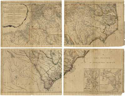
"An Accurate Map of North and South Carolina With Their Indian Frontiers . . . ," 1775. Click on the image for a full view and description of the map.
This map, aptly titled "An Accurate Map of North Carolina," shows the northern and southern boundaries of North Carolina. It also shows known Native American paths, rivers, and major towns. Tennessee hasn't been outlined yet, but we can see Mecklenburg County. What other counties can you see? Can you find Orange County? Johnston County?
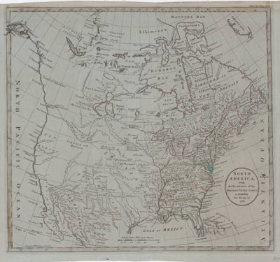
"North America with the boundaries of the thirteen United States, as settled by the Treaty of 1783," circa 1780s. Click on the image for a full view and description of the map.
This map, printed in 1783, shows all thirteen colonies after the Revolutionary War. At this time, North Carolina is shown stretching all the way to the Mississippi River. Western North Carolina, now Tennessee, is shown as the Cherokee area.
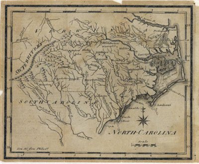
"North Carolina," 1795. Click on the image for a full view and description of the map.
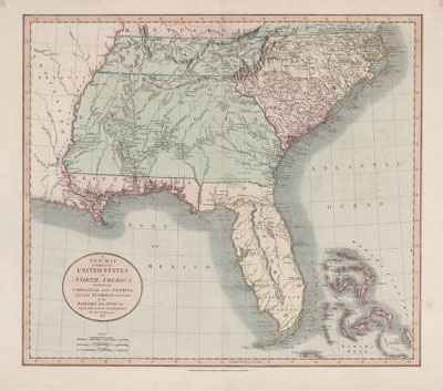
"A new map of part of the United States of North America," 1806. Click on the image for a full view and description of the map.
In the 1790s, the government of Tennessee moved to become a separate state. This map, drawn in 1794, shows the Tennessee Area. The next map, drawn in 1795, shows the new Western boundary.
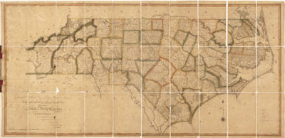
". . . First actual survey of the state of North Carolina," 1808. Click on the image for a full view and description of the map.
By the end of the 18th century, North Carolina was a fully-formed state with permanent boundaries. This 1808 survey map by Price and Strother shows clear western, northern, and southern borders. In addition, North Carolina's most famous towns are shown. Can you find Chapel Hill? Do you see the state capital, Raleigh? Can you find Charlotte in Mecklenburg county?