
Lesson Plan - Erosion in the Outer Banks
A Lesson Plan for Grades 10-12 Environmental Science and English
By Jennifer Job, School of Education, UNC-Chapel Hill
Objectives: Students will show understanding of the different perspectives on erosion in the Outer Banks over the past century implementing research and map comparisons between Google Earth and early 20th century Coastal Maps. This lesson assumes a basic knowledge of erosion terms as well as latitudinal and longitudinal direction.
This lesson plan is available as a formatted worksheet which can be printed and distributed. Download the worksheet by clicking the title: erosion_k12.pdf
Time Required: 70 minutes.
Materials:
- Handout (.pdf)
- Computer lab equipped with:
- Internet access
- Google Earth
- An image manipulation program such as MS Paint or Photoshop
- LCD Projector
Teacher Instructions:
- Distribute Handout (.pdf) with instructions (this particular project looks at two dates—it can be extended)
- Divide students into pairs to work on this project
- Collect products at the end of the time period.
Assessment:Images may be presented on the LCD projector to compare results. Students may also be assessed by the completeness of the project and mastery of concepts.
Are the Outer Banks Disappearing?
Erosion is a much-debated topic amongst environmentalists. For this project, you will come to your own conclusion about erosion in the Outer Banks and form an argument as to what preventative measures should be taken there.
The Product: A one-page presentation including a generated graphic and a 400+ word argument.
The Process:
I. Creating Your Image
- Go to the North Carolina Maps page for for Coastal Maps (http://web.lib.unc.edu/nc-maps/cgs.php).
- Click on Cape Hatteras.
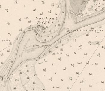
- Find a map that clearly shows your area between the dates of 1895 and 1910 (we want to look at approximately 100 years of erosion).
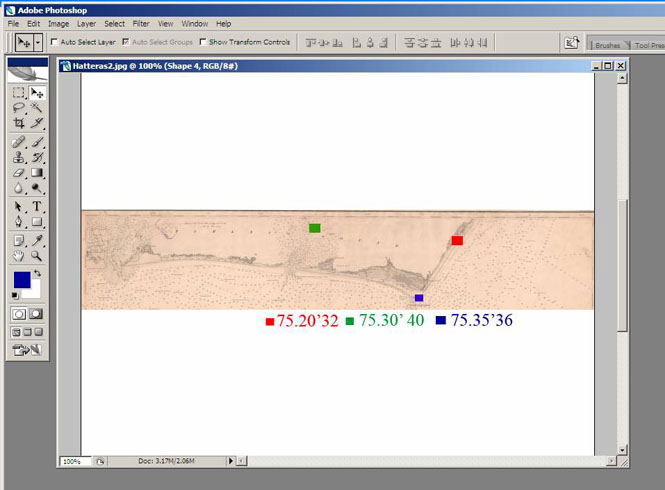
- Using the toolbar, cut a section of the Cape Hatteras that includes as much of the land area as possible from the map out of the site and save the picture (either in your own server space or wherever your teacher directs you). Label the picture with the place and date (e.g., CapeHatteras1898). Don't close the North Carolin Maps site.
- Open the picture in a graphics program such as MS Paint or Photoshop. Using the original map as a guide, mark three clear points of latitude and longitude for reference—one at the top, one at the left, and one at the right. Either use different colors for each point and put a legend at the bottom of the picture, or type the latitude/longitude directly onto the point. Remember to be specific—it will help you later!
- Re-save the picture.
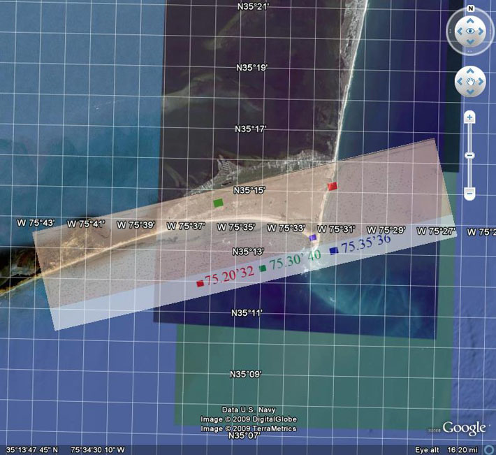
- Open Google Earth. In the location box, type in "Cape Hatteras, NC."
- Make sure all of the points-of-interest boxes on the left side are unchecked so all you see is the land mass. Make the window as wide as the screen so it is easy to work with.
- Under the "View" menu on the top toolbar, check the box marked "grid." This will show you the latitude and longitude grids on the map.
- Under the "Add" menu on the top toolbar, click "image overlay."
- Title the image overlay "Cape Hatteras."
- Click the "browse" box and find your previously saved picture.
- You want to line up your picture of Cape Hatteras with the Google Earth image of Cape Hatteras using your points of reference. Match your points to the correct latitude/longitude marked on the Google Earth image. You can widen/shrink the image with the outside lines, move the image around with the center cross, and rotate the image with the diamond to the left of the center. You must line up the points of latitude and longitude to correctly analyze the picture.
- Once the maps line up, use the transparency slide in the window to lighten the image until you can see through it enough to compare. You will probably want the slide to be 2/3 towards the Opaque side. Remember, you want to see the early Cape Hatteras picture as well! It will look something like this:
- Once you have the image the way you want it, click "Ok" in the "Image Overlay" window. Then, under the "File" menu at the top toolbar, click "Save" and then "Save Image." Save the image where you saved your first picture, but name it something different.
- Open this new picture in the graphics program. Using circles, highlighting, or some other method, mark where you see differences in the land between the early 20th century and now.
II. Research
Read the following articles. While you are reading, create a table with headings marked "Causes of Erosion," "Level of Erosion," and "Solutions." In the table, jot down notes from each article about what is said about the causes of erosion, the level of erosion in the Outer Banks, and what measures are recommended to stop it:
- http://www.dailytarheel.com/online_extras/online_exclusives/outer_banks_residents_look_to_long-term_erosion_prevention
- http://coastal.geology.ecu.edu/NCCOHAZ/maps/erosion.html
- http://www.aegweb.org/i4a/pages/index.cfm?pageid=4083
- http://www.erosion.com/armycorp.asp
III. Creating Your Document
- Open up a new document in a word processing program, such as MS Word.
- Give your document a title and be sure to put your names on it!
- Insert your saved Google/NC Maps image into the top half of the document.
- In the bottom half of the document, write a 400+, single spaced letter to a newspaper editor in a paragraph answering the following questions:
- Do you see evidence of erosion in the Cape Hatteras area? Where?
- Considering the articles you read, what do you think is the major cause of this erosion? Which article seemed the most convincing?
- What (if anything) should be done to slow the erosion of the area? If you argue nothing should be done, explain why.
- Who seems to be doing the best work in preventing erosion? What from the articles makes you think so?
Save your document and turn it in.
North Carolina Curriculum Alignment
Environmental Science SCOS
4.01 Evaluate erosion and depositional processes:
- Formation of stream channels with respect to the work being done by the stream (i.e. down-cutting, lateral erosion, and transportation).
- Nature and characteristics of sediments.
- Effects on water quality.
- Effect of human choices on the rate of erosion.
English III Language Arts SCOS
2.01 Research and analyze ideas, events, and/or movements related to United States culture by:
- locating facts and details for purposeful elaboration.
- organizing information to create a structure for purpose, audience, and context.
- excluding extraneous information.
- providing accurate documentation
3.03 Use argumentation for:
- interpreting researched information effectively.
- establishing and defending a point of view.
- addressing concerns of the opposition.
- using logical strategies (e.g., deductive and inductive reasoning, syllogisms, analogies) and sophisticated techniques (e.g., rhetorical devices, parallelism, irony, concrete images).
- developing a sense of completion.